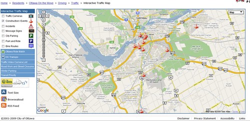
The City of Ottawa’s award-winning interactive traffic map

The City of Ottawa walked away with a GTEC 2009 Distinction Award in the municipal category for the city’s Interactive Traffic Map last night.
In December 2008, Ottawa was paralyzed by a transit strike and congestion was filling the city’s roads and highways as more cars were suddenly being driven. Needless to say, drivers were frustrated.
“There was a demand for more information,” said Mark Faul, a business analyst in the City of Ottawa’s e-Media division presenting the web app at GTEC 2009.
The city already had plenty of real-time traffic data, but no useful way for Ottawa residents to access it.
Realizing something needed to be done, systems communication and video section manager for the city’s public works department Motaz Aladas sprang into action, working with the city’s IT department to build and launch a web app quickly.
Using the Google maps API as well as Ruby on Rails and MySQL, they put together a mash-up that allows users to view traffic cameras, see areas affected by major incidents like car accidents or fires, locate city parking lots and more.
The first version of the mash-up was far from perfect. It wasn’t very pretty and had security vulnerabilities that weren’t patched immediately in the interest of launching as fast as possible.
The site went live on the third week of the bus strike.
“We mashed-up something really quickly and put it online so people could use it right away,” said Aladas.
Since the strike, time has been taken to improve the traffic map. It looks better and security holes have been plugged as well as working to add new features.
The city staff have been experimenting with Twitter integration while looking to add features like snow removal parking restriction info, better live traffic flow information, real-time capacity updates for city parking lots and adding the same information for neighbouring city Gatineau, Quebec.
Currently the site averages 600 visits per day, spiking up to 2000 during major events, like U.S. President Barack Obama’s visit in February.
Finally, the team working on the map would also like to open up more City of Ottawa data to Google Maps to allow users to make their own mash-ups.


