Waze Sets Course for Revolutionizing Driving Data
 It’s cold. It’s raining.
The coming of spring in Vancouver is always the same: overcast skies, drizzle, panicked defense of my eyeballs from umbrella stems. I’m standing outside on the street, hugged under an awning to avoid the rain, staring at my phone.
I’m going to demo an mobile application called Waze today. Who better to do it than someone who’s green to navigation apps—which at this point in the story, is the extent of my knowledge about Waze, it’s a nav app—and a man that doesn’t drive?
I can’t lie though; I was actually excited, until I realized what I was doing. Standing here, about to hop into a strangers car, to demo something I hadn’t even really checked out. My mother would be proud.
I decided that the initial reaction would greatly color my opinion of the company behind Waze. Would it be a pack of youths, crammed into a beater hatchback? Or would it turn out to be a white, unmarked van, with no windows and “free app” written on the side in spray paint? Neither, actually; it was a brand-new, rented SUV with Waze decals magnetized to the side. Classy approach, Waze. Touché.
Getting over the fancy feel, we dove right into the app demo. Waze is a old app, by app standards, but they’re really making headway lately, and the end result is a more useful product. You see, Waze isn’t a normal map/nav application; it’s crowd-sourced map, and live-traffic data. It also just so happens to get you to your destination (as almost a side-note).
The impressiveness comes in the form of function. If you’re a driver, and select the aptly named driver mode, the app will keep you from using the app while the gyroscope of the mobile device is telling the app that you’re currently moving. It’s hands-free, AND it smacks you when you try to drive and do things.
The Passenger mode is far more exciting, as you have time to really use the rest of the application. Now, you can use these things when in Driver mode, but the application wants you to wait until you’re at a red light, or stop sign, or actually stuck in traffic. This is where the app really shines. As a passanger, you can update routes, and send information to your fellow “Wazers” (the cute term the developers call their users).
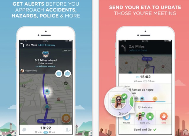
On the road (in the app), you see pings all over the place, those are other drivers making updates, and that’s when the real-time info takes affect. Stuck in traffic? Update Waze. Simply open your reporting screen, hit traffic, choose a severity, and every other user’s map will update to show red roads (traffic) taking into account the route you’re on, and your GPS location.
You can report Police Traps, Accidents, Hazards (like the filming we ran into during our demo), and even gas prices. In your app, you can set things like your favorite gas station (or whichever one you’ve got the points card at), and you can tell the app you need gas on your trip, and it will re-route you to your preferred station.
It’s important to note that you can do all of this with voice commands as well.
This is how you get the most efficient travel experience possible. Constantly updated maps thanks to a large (and ever-growing) user-base.
Vancouver, has 22,000 monthly active users, which is more than enough to get standard traffic updates. However, in Toronto, where they’ve got 175,000, or Montreal, where they have 103,000, the data is more refined, as is the outcome of crowd-sourced live data. The more you have, the more accurate things are.
There are two sets of sources for Waze, Map Editors, and Drivers/Passengers (as explained above). Map editors, like wiki editors, are Waze-approved people who are given a chunk of the worlds map (normally locally) that they are in charge of keeping up-to-date. Street name gets changed? Edit. Notable closures for long periods of time? Edit. These Map Editors, along with the live-data drivers/passengers, make Waze information superior to other applications that attempt to guide you.
The user-interface is gorgeous, and easy to understand. There’s even a handy “ETA” tool where you can send your calculated arrival time to a quick-list of favorites. During the demo, we were “on our way to mum’s” and gave her an easy update of our current location, and how far away from her place we were (assuming you’ve put their address in your favorites list contact information) with the quick tap of two buttons in succession.
Sure, there are easier, cleaner, more straightforward maps, but Waze isn’t trying take their place—they’re playing a entirely different sport.
Waze provides real-time, anonymous, proprietary incident and slow-down information directly from the source: drivers themselves.
I have a strange feeling that we’re only going to hear the name Waze more, and more, in the coming years. There’s a lot here to build on, and I expect epic innovations to continue from this group.


